

Weekly Fishing Report: North South
Lake Michigan
Lake Michigan offers anglers a variety of experiences from shore fishing in the bustling harbors and lagoons of Chicago to launching a day's adventure from one of many marinas. Whether you seek a tasty meal of yellow perch or the excitement of landing a chinook salmon on a day charter, Lake Michigan is a true destination for the Illinois Angler.
Harbors


Many species of sport fish are found in Chicago harbors throughout the year and others only inhabit harbors during certain times of the year. The Chicago Park District has designated certain areas of these harbors open to anglers fishing from shore.
Marinas
| Marina | Location | Operator | Capacity | Services | Fee |
Restrictions |
|---|---|---|---|---|---|---|
| North Point Marina | 7th Street in Winthrop Harbor, IL | Department of Natural Resources (847) 746-2845 |
10 boat launching lanes 200 parking spaces for car and trailer |
|
None |
Ramp is open 24hrs April 1 to October 31, weather permitting |
| The Port of Waukegan (Waukegan Harbor) | Harbor Place, Waukegan, IL | Waukegan Port Authority (847) 244-3133 |
4 boat launching lanes 600 parking spaces for car and trailer |
|
$10 (daily parking) $20 (public launch) Call for slip pricing |
Ramp is open 24hrs April 1 to November 1, weather permitting |
| Park Avenue Launch Ramp | Park Avenue in Highland Park | Highland Park District (847) 831-3810 |
1 boat launching lanes 25 parking spaces for car and trailer |
|
$15 (resident daily launch M-F/$35 weekend) $10 (resident beach launch/$20 weekend) Nonresident fees are double the rate of resident fees. |
Ramp is open April 1 to October 15 Hours: 7 AM to 9PM; not staffed after Labor Day Site has no dockage stalls or mooring buoys |
| Lloyd Park in Winnetka | Lloyd Place in Winnetka | Winnetka Park District (847) 501-2040 |
1 boat launching lanes 63 parking spaces for car and trailer |
|
$15 (resident daily launch M-F/$35 weekend) $5 (resident beach launch/$15 weekend) Nonresident fees are double the rate of resident fees. |
Ramp is open May 1 to October 15 Hours: 8 AM to dusk (M-F); 7 AM to 9 PM (weekend) Site has no dockage stalls or mooring buoys Maximum boat length 25 feet |
| Evanston Launch Ramp | Church Street in Evanston | City of Evanston (847) 448-4311 |
2 boat launching lanes 20 parking spaces for car and trailer |
|
$250 resident seasonal only $500 nonresident seasonal only Seasonal launch permits on sale starting April 1 |
Ramp is open May 1 to October 31 Hours: 7 AM to 10 PM Call regarding further restrictions |
| Diversey Harbor in Lincoln Park | Diversey Parkway (2800 North), Chicago | Chicago Park District (312) 742-7762 |
3 boat launching lanes 60 parking spaces for car and trailer |
|
$26 (daily) |
Ramp is open May 1 to October 31 No launching after 8 PM Maximum boat length 23 feet |
| Burnham Harbor in Burnham Park and Northerly Island | 12th Street (1200 South), Chicago | Chicago Park District (312) 747-7009 |
3 boat launching lanes on west side 37 parking spaces for car and trailer on west side |
|
$26 (daily) |
Ramp is open May 1 to October 31 No launching after 8 PM Maximum boat length 23 feet |
| 31st Street Harbor | 3100 South, Chicago | Chicago Park District (312) 225-6464 |
2 boat launching lanes 12 parking spaces for car and trailer on west side |
|
$26 (daily) |
Ramp is open May 1 to October 31 No launching after 8 PM Maximum boat length 30 feet |
| Jackson Harbor in Jackson Park | Hayes Drive (6300 South), Chicago | Chicago Park District (773) 288-7106 |
2 boat launching lanes on east side 80 parking spaces for car and trailer on east side |
|
$26 (daily) |
Ramp is open May 1 to October 31 No launching after 8 PM Maximum boat length 23 feet |
| Calumet Harbor | 95th Street, Calument Park, Chicago | Chicago Park District (312) 742-8520 |
3 boat launching lanes on east side 100 parking spaces for car and trailer on east side |
|
$26 (daily) |
Ramp is open all year No launching after 8 PM Maximum boat length 23 feet Site has no dockage stalls or mooring buoys |
Fish Species in the Illinois Waters of Lake Michigan
Perch Fishing: Open all year except from July 1-31
May and June are prime fishing times. the daily limit is 15. Best place to fish are found along breakwalls and piers that drop off into deep (12 to 20 feet) water. Softshell crayfish, spikes, minnows, spinners and jigs are all great baits to use for perch.
- January - February
Lakefront and Harbors: Perch, Panfish and Trout - March - April
Lakefront and Harbors: Coho Salmon and Smelt
Lagoons: Early season Bluegill and Crappie - May - August
Lakefront and Harbors: Perch (except for closed season July 1 - July 30), Panfish, Carp and Smallmouth Bass, Freshwater Drum (aka Sheephead, Silver Bass)
Lagoons: Bluegill, Channel Catfish and Largemouth Bass
Channel catfish (12,500+ fish) and bluegill (56,000+ fish) are stocked by the IDNR in the following lagoons in June, July, and August: Auburn, Columbus, Douglas, Garfield, Gompers, Humboldt, Jackson, Marquette, McKinley, Sherman, and Washington. Crappie, largemouth bass and carp can be found too. - September - December
Lakefront and Harbors: King and Coho Salmon, Brown Troud, Steelhead and Perch, Freshwater Drum
Lagoons: Bluegill and channel Catfish (mainly in September and October)
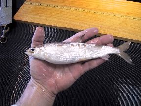
Lake Michigan Smelt Fishing
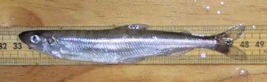
Rainbow smelt (Osmerus mordax) are a naturalized exotic in Lake Michigan. Originally transported from the east coast and stocked in Crystal Lake, Michigan, smelt were first reported in Lake Michigan in 1923. The smelt population expanded and reached high levels by the early 1940s.
Smelt begin spawning in Lake Michigan as early as March 17 or as late as April 28. The peak of the run, and the best fishing, lasts about a week, usually starting between April 10 and 20. Regulations for smelt fishing apply to the type of equipment used; there are not bag limit or length restrictions. The smelt fishing season is March 1 through April 30.
An Illinois sport fishing license is required to fish for smelt. The best places to fish for smelt are along the Chicago Park District property and at beaches from Waukegan to the Illinois-Wisconsin state line.
Find the latest updates here:
- Chicagoland Fishing - forums with daily updates
Smelt Fishing Gear
A gill net made of nylon thread is the most common type of gear used in Illinois. Threads are from ½ to ¾ inch apart in a crisscross manner and legally must not exceed 1 ½ inches diagonal stretch. There are floats on the top line and lead weights on the bottom line. the net forms a fence-like obstruction in the water and when smelt try to swim through, they become entangled. Some special equipment is required to maneuver the net in and out of the water. A one to two pound anchor, which has flexible wire extensions that grab the bottom, is attached to a heavy line and thrown our 50 to 100 feet from shore. This line is pulled as tight as possible, without loosening the anchor, and then tied to a pole, pier railing, or other stationary object. A line of about 25 feet is fastened to the back of the net and the other end of this line is secured to the shore. A trolley, which is a one half to one pound weight suspended below two wheels, is tied to the forward end of the net and then attached t the anchor line. The bet line is used to pull in the net and the trolley rides up the anchor line. Most fishermen raise their nets every 5 to 10 minutes. Gill nets up to 12 feet long and 6 feet deep may be used legally, and an angler is limited to one smelt fishing device at any one time.
A large dip net or boom net, up to 12 feet in diameter, is another smelt fishing device. Mesh size may not be less than one inch diagonal stretch. It is suspended from the top of a portable boom which is tilted to hang over the water. The net is lowered into and raised out of the water by a rope or cable attached to a winch. Smelt are removed by a long-handled scoop.
A seine is still another type of gear used for smelt fishing. It
is used on the beaches and is pulled through the water by two persons
who usually wear waders or hip boots. When smelt are running heavy,
one seine haul will provide enough fish to fill a minnow bucket.
the mesh of a seine is made of nylon, either woven or knotted, and
is 1/8 or ¼ inch square. A legal smelt seine may not exceed
12 ft in length and 6 ft in depth and may not have mesh greater
than 1 ½ inches diagonal mesh stretch. All fish other than
smelt taken in smelt fishing devices must be immediately returned
to the water.
Lake Michigan Salmonid Stocking
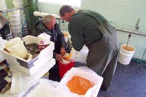
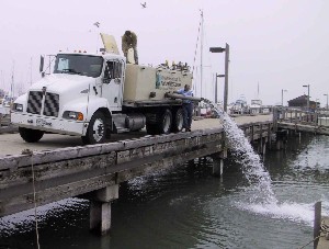
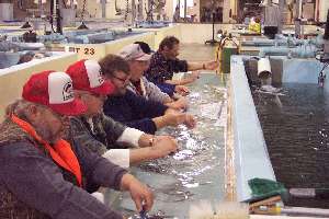
Chinook salmon, coho salmon, brown trout and two strains of rainbow trout are raised at the Department’s Jake Wolf Fish Hatchery. Chinook salmon eggs are collected from mature fish in the Little Manistee River (Michigan) by Illinois and Michigan Departments of Natural Resources personnel; coho salmon eggs are collected from mature fish in the Platte River (Michigan). Eyed eggs (developed to the point that eyes can be distinguished inside egg) of brown trout and Arlee-strain rainbow trout are received from US Fish & Wildlife Federal hatcheries, and fertilized Skamania-strain rainbow trout eggs are received from an Indiana Department of Natural Resources hatchery. These fish are grown at the hatchery and stocked by the hatchery staff in early or late summer, depending on the species. Lake trout stocked in our waters are hatched and raised at one of the US Fish & Wildlife Federal hatcheries; these fish are then stocked offshore using the Service’s vessel Togue.
 There have been several studies over the years that have required us to be
able to identify the age, strain, or stocking location
of salmonids stocked in our waters. A highly visible and relatively
inexpensive method of marking fish is to clip off one or a combination
of fins. One ongoing project involve clipping fins on Chinook salmon
stocked in Waukegan Harbor to assess fall (spawning) returns to
that stocking site and to estimate mortality rates. We also began
clipping fins on both strains of rainbow trout in 1996 in response
to Michigan’s request that all stocked rainbow trout be marked
to distinguish them from naturally produced rainbow trout.
In partnership with the US Fish and Wildlife Service, the IDNR (among other State agencies) began a coded wire tagging program for Chinook salmon in 2010. Coded wire tags are inserted into the snouts of Chinook salmon smolts and enable researchers to determine stocking site fidelity, movements, and survival. Lake trout have received coded wire tags for several years now and, like Chinook salmon, much of the same information can be collected from tag returns; additional information includes the strain and source location of tagged lake trout.
There have been several studies over the years that have required us to be
able to identify the age, strain, or stocking location
of salmonids stocked in our waters. A highly visible and relatively
inexpensive method of marking fish is to clip off one or a combination
of fins. One ongoing project involve clipping fins on Chinook salmon
stocked in Waukegan Harbor to assess fall (spawning) returns to
that stocking site and to estimate mortality rates. We also began
clipping fins on both strains of rainbow trout in 1996 in response
to Michigan’s request that all stocked rainbow trout be marked
to distinguish them from naturally produced rainbow trout.
In partnership with the US Fish and Wildlife Service, the IDNR (among other State agencies) began a coded wire tagging program for Chinook salmon in 2010. Coded wire tags are inserted into the snouts of Chinook salmon smolts and enable researchers to determine stocking site fidelity, movements, and survival. Lake trout have received coded wire tags for several years now and, like Chinook salmon, much of the same information can be collected from tag returns; additional information includes the strain and source location of tagged lake trout.
Annual Stocking Reports
2014 Stocking Report
2013 Stocking Report
2012 Stocking Report
2011 Stocking Report
2010 Stocking Report
2009 Stocking Report
2008 Stocking Report
2007 Stocking Report
2006 Stocking Report
2005 Stocking Report
2004 Stocking Report
2003 Stocking Report
Spring Index Survey
Alewife, rainbow smelt, and bloater chubs comprise most of the food for Lake Michigan salmonids. The primary objective of the spring index survey, started in 1987, is to assess the status of these forage fish. Knowing the population characteristics is important because these species are naturally reproducing, while the salmon and trout are primarily stocked. Identifying changes in the populations of the forage fish helps to determine if changes in stocking rates of the salmon and trout are necessary to keep from overtaxing the food supply.
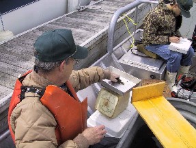
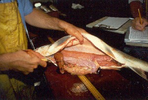
Program biologists sample with gill nets set at several depths, covering the shallow water areas close to shore out to 270 ft. Sampling occurs near Waukegan (even years) or Chicago (odd years) in spring. These two areas were chosen for sampling because of the differences in water depths within Illinois jurisdiction and the resulting differences in fish species abundance and composition. Sampled fish are counted, measured, and weighed. Sex and maturation (e.g., egg development) are also assessed, and otoliths are collected to determine ages. This survey also provides additional information on yellow perch and lake trout populations.
The objectives of spring index sampling are to:
- Monitor changes in the relative abundance of alewife, rainbow smelt, and bloater chubs between years
- Monitor growth indices and sex ratios
- Collect age-composition data to determine recruitment rates
This survey is also the first indication of over-winter survival of juvenile yellow perch hatched during the previous year.
Lakewide Assessment of Predators
Management of the Lake Michigan fish community id the shared responsibility of the four states surrounding the lake and the Chippewa /Ottawa Resource Authority. Previously, each state group assessed species health and abundance in its waters independently and by different methods. There was little coordination and interpretation of data from the different sources was difficult. A move to standardize sampling in the late 1990s led to development of Lakewide Assessment Plans. The first of these Plans initiated, the Lakewide Assessment of Predators, focuses on the three top predators in the lake: Chinook salmon, lake trout, and burbot.
Program biologists sample adult Chinook salmon, lake trout, and burbot with gill nets near Waukegan in spring. Sampled fish are counted, measured, and weighed. Sex and maturation (e.g., egg development) are also assessed. Otoliths are collected to determine ages and stomachs are collected to determine diet composition. Indicators of fish health are also assessed including: fat content, condition of various internal organs, and proportion of weight to length. The incidence of lamprey wounds and scars is recorded, and fin clips and coded wire tags are used to determine where and when the Chinook salmon and lake trout were stocked.
Lakewide assessment results are presented in annual and multi-year reports prepared jointly by biologists representing each management agency on Lake Michigan. The objectives of the lakewide assessment of predators sampling are to determine growth, population mortality, age-specific diet, juvenile recruitment, and general health of the three predators.
Yellow Perch Survey
Historically, yellow perch abundance in the Illinois waters of Lake Michigan has varied greatly. Years of high harvest levels have been countered by years of poor harvests. Gill net assessments conducted since 1976 by the Illinois Department of Natural Resources show that population levels have fluctuated. The relatively recent additions of zebra mussels and round goby to Lake Michigan have the potential to alter the environment in which yellow perch thrived in the past. Additionally, the ruffe which was detected in northern Lake Michigan in 2002 has displaced yellow perch in other waters where it has become established. These potential changes require that managers continue to monitor yellow perch population levels and assess protective measures to sustain the population.
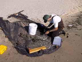
Program biologists sample adult yellow perch with gill nets near Waukegan and Chicago in early summer. Sampled fish are counted, measured, and weighed. Sex and maturation (e.g., egg development) are also assessed, and otoliths are collected to determine ages. Juvenile yellow perch are sampled with a beach seine at seven sites along the Illinois shore. These small perch are counted and measured, and the abundance of the young-of-the-year (YOY) is used as an indicator of whether the adult population will increase or decrease in the future.
The objectives of yellow perch sampling are to:
- Monitor changes in the relative abundance of yellow perch between years
- Monitor growth indices and the sex ratio for yellow perch
- Collect age-composition data to determine recruitment rates
- Evaluate anticipated recruitment through YOY abundance
Summer harbor assessment
Several sport and non-sport fish species inhabit Illinois harbors and nearshore areas of Lake Michigan in summer. Concurrent with the decline of the yellow perch fishery over the past decade, there has been an increasing demand for sportfishing opportunities in nearshore areas and an increased interest in the nearshore sport fishery, especially for black bass. Increases in the abundances of these warm-water fish species and angler effort for non-perch and non-salmonid fish species in the Illinois waters of Lake Michigan are evident from sport angler creel data.
This assessment program was developed to monitor the relative abundance and distribution of nearshore sport fish species and to determine whether those species were susceptible to overexploitation by tracking changes in relative abundances over time. In addition to biological information (e.g., length and weight), an understanding of seasonal dispersal patterns of the sport fish associated with the nearshore fish community is required to effectively manage these species.
Program biologists sample four harbors by electrofishing to determine which species are present and available to anglers in nearshore areas during summer. Sampled fish are counted, measured, and weighed, and PIT (Passive Integrated Transponders) tags are implanted in largemouth and smallmouth bass to track growth and movements of individual fish. A subsample of those fish are collected to determine ages.
The objectives of the summer harbor sampling are to:
- Determine fish species composition of select Illinois harbors and nearshore areas of Lake Michigan
- Monitor changes in the relative abundances of smallmouth and largemouth bass and other sport fish between years
- Evaluate intra- and inter-annual fidelity of smallmouth and largemouth bass to harbors
- Monitor growth indices for smallmouth and largemouth bass and rock bass inhabiting these harbors
- Collect age-composition data which may eventually be used to determine recruitment rates of the most abundant fish species
Summer 2012 Harbor Annual Report
Fall harbor assessment
Salmonids were first stocked in Illinois waters in 1976 and salmonid stocking in Illinois currently accounts for approximately 6% of the lakewide stockings. The Illinois annual stocking plan includes 304,000 Chinook salmon, 300,000 coho salmon, 100,000 rainbow trout, and 100,000 and brown trout.
Program biologists sample four harbors by electrofishing to determine the abundance of salmonids in Illinois harbors in the fall. Sampled fish are counted, measured, and weighed. Sex and maturation (e.g., egg development) are also assessed, and otoliths are collected from Chinook salmon to determine ages. We assess the return rate of salmonids to the harbors in which they are stocked by clipping off different fins in different years and monitoring the incidence of fin clips on salmonids returning to the harbors in the fall.
The objectives of the fall salmonid harbor sampling are to:
- Collect fish flesh samples to update the Illinois Fish Consumption Advisory
- Collect data on returning fin-clipped fish and assess movements and fidelity to stocking sites
- Collect information on the condition and abundance of returning fish to address questions regarding health of the fish and the effects on the forage base
Fall 2013 Harbor Annual Report
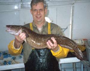
Fall Lake Trout Survey
Lake trout were historically the top predator in Lake Michigan and supported the fishery supported the largest harvest of the Great Lakes. Lake trout were extirpated from Lake Michigan by the 1950s due to overharvest, habitat degradation, and predation by the exotic sea lamprey. Stockings of lake trout began in 1965 to reestablish lake trout in the lake. Rehabilitation has involved control of sea lamprey, determination of appropriate strains of lake trout since the native strains were lost, and management of harvest and vectors impairing fish habitat. The primary objective of the 1985 Lake Michigan Lake Trout Restoration Plan of the Lake Michigan Technical Committee was to “establish a self-sustaining lake trout population, able to yield an annual harvest projected conservatively at 500-700 thousand fish weighing 2.5 million pounds.” The achievement of this goal relies on the natural reproduction of lake trout. To date however little to no natural reproduction of lake trout has been observed.
Program biologists sample adult lake trout with gill nets at two spawning reefs and one shore site near Waukegan in late fall. Sampled fish are counted, measured, and weighed. The incidence of lamprey wounds and scars is recorded, and fin clips and coded wire tags are used to determine where and when the fish were stocked. Sex and maturation (e.g., egg development) are also assessed. Otoliths are collected to determine ages and stomachs are collected to determine diet composition.
The objectives of fall lake trout sampling are to:
- Monitor changes in the relative abundance of spawning aggregations of lake trout between years
- Monitor growth indices and the sex ratio for lake trout
- Collect age-composition data
- Identify which strains contribute to spawner stock
- Evaluate mortality due to sea lamprey predation
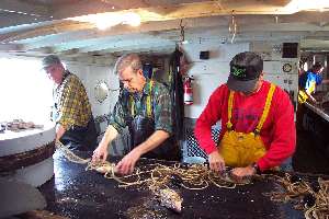
Charter Boat Harvest Survey
Non-native salmonids have become an integral part of the Lake Michigan fish community and the sport fishery. Pacific salmon and various trout species have been stocked in Lake Michigan since the late 1960s. The purposes of stocking these fish are to re-establish self sustaining lake trout populations, control alewife population growth, and provide sport fishing opportunities.
Charter boat operators receive a fee to provide sport anglers access to offshore fishing opportunities for salmonids. A catch (harvest) reporting system is mandated through Illinois statutes governing charter boat licensees that engage in such activities in Illinois waters (Fish Code of Illinois, Section 5/10-135). Charter boat operators submit monthly reports detailing the number of salmonids harvested, number of anglers and amount of time spent fishing, and general location information. These harvest and effort data are vital to understanding the abundance of predators and effects on prey fish populations.
Charter Boat Annual Reports (pdf)
2013 Charter Fishery Report
2012 Charter Fishery Report
2011 Charter Fishery Report
2010 Charter Fishery Report
2009 Charter Fishery Report
2008 Charter Fishery Report
2007 Charter Fishery Report
2006 Charter Fishery Report
Basin Report 1996-2006
Habitat Mapping
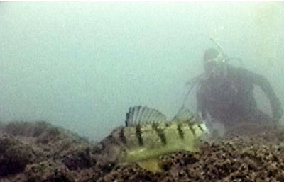
In simplest terms, habitat is the natural environment where fish live, and it is defined by where they can find food, shelter, and breeding grounds. In the Great Lakes, fish habitat has been degraded or fragmented in many coastal areas with the hardening of shorelines and loss of "run of the river" due to dams. Both nearshore and offshore areas of Lake Michigan also provide important habitat for many fishes. For example, Yellow Perch prefer to spawn in areas with vegetation or hard substrate, while Lake Trout primarily spawn on rocky reefs. These in-lake habitats have also been degraded, directly and indirectly, by invasive zebra and quagga mussels. In order to rehabilitate essential fish habitat and minimize impacts from future disturbances, fisheries managers must first know what habitat is available and how it is being utilized by fish. One approach to documenting fish habitat is to identify areas inhabited by fish, then conduct surveys on those areas to quantify the bathymetry (depth and shape of underwater terrain) and bottom substrate characteristics of those areas. From there, the data is used to generate maps of potential fish habitat. Once the preferred habitat characteristics have been identified, they can be used to look for other areas that may be crucial for specific life stages of fish. This approach is currently being used to map Lake Trout spawning habitat in Illinois waters of Lake Michigan through a collaborative project with the Illinois Natural History Survey (INHS).
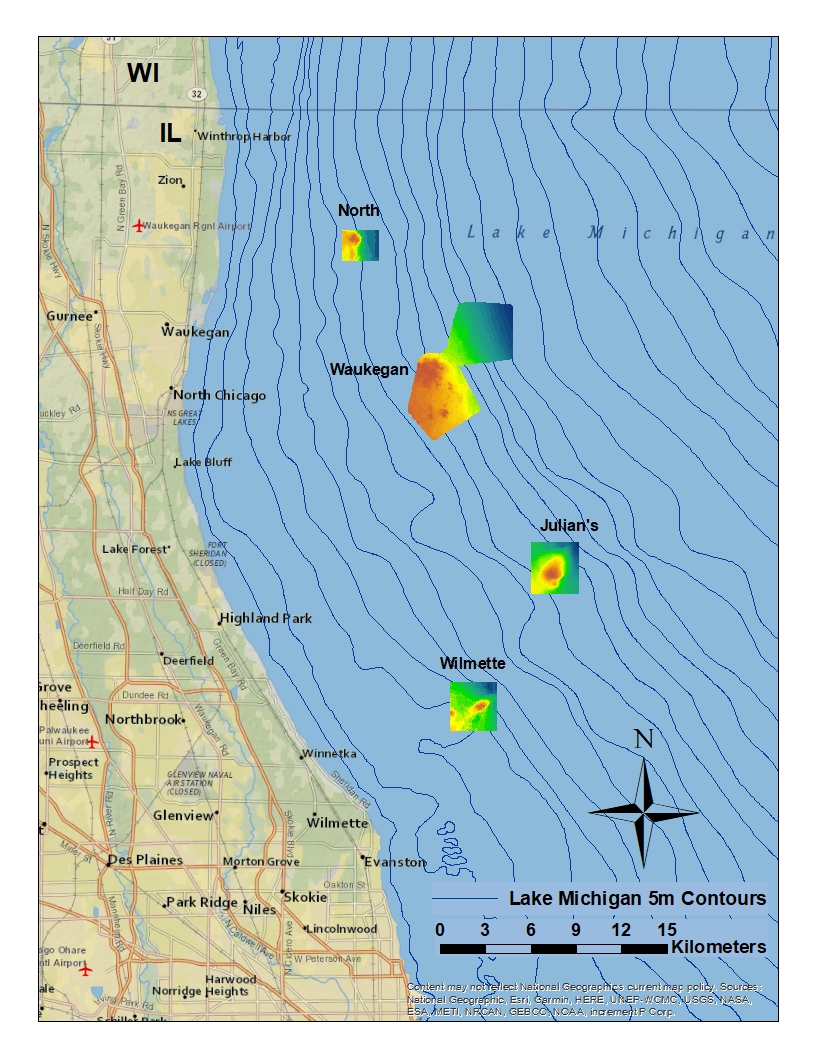
Lake Trout stocking in Lake Michigan has been ongoing since the 1960s, and until recently, has had only limited success in re-establishing naturally reproducing populations. Successful Lake Trout reproduction to the fry stage has been documented for the past two years at Julian's Reef, an historic offshore spawning site in southwestern Lake Michigan. Additionally, annual population monitoring by Illinois DNR during the fall spawning season has shown high abundances of mature Lake Trout at Julian's and Waukegan reefs, and since 2012, 40% or more of those adult Lake Trout were of natural origin. (Please read:Progress Toward Lake Trout Rehabilitation). This is the highest proportion of naturally-produced Lake Trout documented by state management agencies around Lake Michigan. These findings imply that natural reproduction is occurring in Illinois waters and have prompted the need to identify and map additional potential spawning habitat within the Illinois portion of the lake.
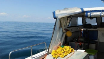
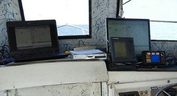
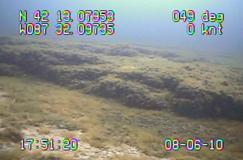
In 2009–2011, researchers with INHS's Lake Michigan Biological Station began the mapping process for Waukegan and Julian's reefs. (Please read:Lake Trout Spawning Habitat). Aboard the RV Sculpin, an echo sounder and GPS were used to develop bathymetry maps and a hydroacoustic towfish was deployed to produce side-scan images of bottom substrate types. A drop camera was then used to confirm substrate types. More recently, bathymetry mapping has been occurring at other offshore reefs (North Reef, additional areas near Waukegan Reef and Wilmette Reef) in Illinois waters where Lake Trout might also be spawning. The geo-referenced, bathymetric maps created from this ongoing work will aid DNR in finding other potential spawning habitat for Lake Michigan's top native predator. Potential outcomes from this work include a better understanding of Lake Trout populations in the lake's southern basin and identification of priority management areas that may be suitable for future habitat protection or rehabilitation projects.
This research is an ongoing collaborative study between the Illinois Natural History Survey and the Illinois Department of Natural Resources. Funding for mapping activities is from the Great Lakes Fish and Wildlife Restoration Act and Federal Aid in Sport Fish Restoration projects F-123-R, F-65-R and F-196-R.
Habitat Maps
Currently available are maps of North Reef, Waukegan Reef, Julian's Reef and Wilmette Reef. You can see their locations on the map below. Click on the reef for an in-depth map with bathymetry. Note the different colored depth scales on each map.


;)
;)
;)
;)
;)
;)
;)
;)
;)
;)
;)