

Choose another river
Mississippi River
Credit: U.S. Geological Survey
Department of the Interior/USGS
U.S. Geological Survey
![]() Upper Mississippi Fishing Guide
Upper Mississippi Fishing Guide
![]() Middle Mississippi Fishing Guide
Middle Mississippi Fishing Guide
Description: The mighty Mississippi River forms the western border of Illinois, where it glides along flowing south the entire length of the state. Its length along the border is 593 miles, and its major Illinois tributaries include the Rock, Illinois, and Kaskaskia rivers. When the Mississippi River reaches its confluence with the Ohio River near Cairo, it is draining wholly or partially 25 states, as well as portions of Canada.
There are two sections to the Mississippi as its flows through Illinois. The upper portion between Alton and East Dubuque near the Wisconsin border consists of a series of reservoirs formed by 14 navigation dams. These pools range from 10 to 47 miles in length and from 3,725 to 33,500 acres in size. In all, some 200,000 acres of water are available for sport fishing in this stretch.
The portion of the river from Alton to Cairo provides 61,266 acres of water. There are no locks and dams on this stretch of the river, which is better characterized as open river with wing dams, side channels, main channel, main channel border and extensive rip rap along the channel banks for protection.
Status of the Sport Fishery: You name it, and the "Father of Waters" has it. Walleye, northern pike and sauger swim in the northern stretches. Crappie, plump bluegills, largemouth bass and bullhead are caught in the myriad of backwater lakes and sloughs. Channel catfish are found virtually everywhere, and the white bass fishery explodes at times.
An unsuspecting fisherman might even hook into a huge sturgeon or snag a giant paddlefish that would most likely swim off with hook, line and sinker. the list of state record fish, the Mississippi has yielded five of those fish, including a 157-pound alligator gar in 1944. This species is exceedingly rare in the state. Other record fish from this great stream are a five-pound, 12-ounce sauger; a 48-pound buffalo; a 57-pound, two-ounce large sturgeon; and a 52-pound paddlefish, which was landed in 1977.
Tailwater areas below each of the roller dams provide fast, turbulent water, which stirs up food and attracts game fish. The best walleye and sauger fishing occurs behind these dams in spring and fall. White bass fishing can be excellent there at times also.
The upper pools are loaded with beautiful, island-studded lakes and sloughs. Many of these areas have little current and exhibit aquatic vegetation. In this type of habitat, which includes stump fields and flooded brush, anglers make fine catches of bluegills, crappies, largemouth bass and bullheads. When winter comes, ice fishing can be found in these spots.
Side channels also are good fishing spots. They may be as wide and as deep as the main channel or may be shallow enough to resemble slough habitat. During normal water stages, these side channels do have currents in them. Fish commonly caught there are channel catfish, white bass, panfish and drum.
Dropoffs from the flats and shallow water to the main channel are good spots for channel cat. Wing dams along the main channel area in this border habitat are excellent fishing areas for white bass, channel catfish, drum, sauger and walleye. Wing dams are relics of an early attempt to control the Mississippi. Many were constructed in the late 1800s to control erosion and divert the current. Consisting of rock and filler, they mostly run at right angles from the shore, and their visibility to the boater depends on the stage of the river. The dams usually extend for some distance and have various shapes.
Emergent dams provide fast, flowing waters at their riverward end. When submerged or partially submerged at higher river stages, they appear to cause a riffle effect in the water. At the riverward ends and immediately downstream of the dikes, deep scour holes often can be found.
In the upper pools, anglers troll above these wing dams and pick up walleye in late fall, winter and spring. It takes some boat-handling skills to control the speed and proper depth of the lure along these dams. Other fishermen may wade out on these dams during low water periods and score consistently on channel catfish and white bass.
Essentially, the river changes from a walleye fishery in the north to a catfish hotspot in the south. The river widens and becomes more turbid the farther south it goes, especially below St. Louis, Mo., where the Missouri River joins it.
The walleye and sauger fishery extends about as far south as Lock 21 at Quincy, but pools north of that are considered hotspots. Wing dams in Pool 12 in Jo Daviess County are excellent spots, as is the tailwater below Lock and Dam 12 at Bellevue, Iowa. Lock and Dam 17 at New Boston also is heavily fished for these species.
Southern reaches of the river produce excellent catches of channel catfish. The side channels and rip rap areas from Monroe to Alexander County, about a 160-mile stretch, are good areas, as is the tailwaters and shoreline areas below Lock and Dam 26 at Alton. Good catches also have been made recently in the Thomson Slough area on Pool 19 near Dallas City and the O'Dell Chute in Adams County.
Sloughs and lakes on each pool that traditionally have been good fish producers, keeping in mind that the wing dams and tailwaters will produce almost anytime.
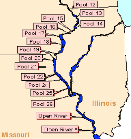
Mississippi River Pools
Click here for maps
Pool 12:
Pool 12 extends from Lock & Dam 12 located near Bellevue, Iowa upstream to Lock & Dam 11 located near Dubuque, Iowa. (see map)
Angling Opportunities: Excellent panfishing, bass and bullhead action can be found on Switzer, Frentress, Fishtrap, Sunfish and Perchangs lake of Pool 12. Kehough and Crooked Sloughs also are good areas. Along Pool 12, panfishing hotspots include Hickory and Miller's Lakes across from Mississippi Palisades State Park where there is excellent camping facilities and at Pin Oak Lake. Other good fishing can be found at Spring Lake National Wildlife Refuge, Potter's Slough south of Thomson and the borrow pit and lake above the dam.
Pool 14:
Pool 14 extends from Lock & Dam 14 located near Hampton, Illinois upstream to Lock & Dam 13 located near Clinton, Iowa. (see map)
Angling Opportunities: Sunfish, Marais D'Osier, Schricker and Steamboat Sloughs are good spots on Pool 14 around the Fulton, Albany and Cordova areas.
Pool 15:
Pool 15 extends from Lock & Dam 15 located near Davenport, Iowa upstream to Lock & Dam 14 located near Hampton, Illinois On the short Pool 15, the lateral dike and tailwaters are good. (see map)
Pool 16:
Pool 16 extends from Lock & Dam 16 located near Muscatine, Iowa upstream to Lock & Dam 15 located near Davenport, Iowa. (see map)
Angling Opportunities: On Pool 16, Sylvan Slough north of Rock Island and Lock and Dam 15 is a good crappie and white bass spot. Farther downstream, Andalusia and Sunfish Sloughs, Goose Pond and Velie Chute can be hotspots.
Pool 17:
Pool 17 extends from Lock & Dam 17 located near New Boston, Iowa upstream to Lock & Dam 16 located near Muscatine, Iowa. (see map)
Angling Opportunities: On Pool 17 below Muscatine, Iowa, Blanchard and Bogus Islands provide good bass, bluegill and crappie habitat, and on Pool 18 some fine fishing can be enjoyed at Bell's Pocket and Boston Bay above New Boston, the Keithsburg Refuge and Spring Slough and the Benton Chute a bit north of Oquawka. Good camping opportunities also are available on this pool at New Boston, Putney's Landing, Delabar State Park and the Big River State Forest.
Pool 18:
Pool 18 extends from Lock & Dam 18 located near Burlington, Iowa upstream to Lock & Dam 17 located near New Boston, Iowa. (see map)
Pool 19:
Pool 19 extends from Lock & Dam 19 located near Keokuk, Iowa upstream to Lock & Dam 18 located near Burlington, Iowa. (see map)
Angling Opportunities: Pool 19 may be the best largemouth bass pool on the Mississippi, because of its size and diverse structure and habitats. The sloughs around Shokokin and Burlington Island and Thomson Slough above Dallas City would be worth probing as would creek mouths below Nauvoo and above Lock and Dam 19.
Pool 20 & 21:
Pool 20 extends from Lock & Dam 20 located near Canton, Missouri upstream to Lock & Dam 19 located near Keokuk, Iowa. Pool 21 extends from Lock & Dam 21 located near Quincy, Illinois upstream to Lock & Dam 20 located near Canton, Missouri. (see map)
Angling Opportunities: There are a number of islands on Pool 20 between Hamilton and Meyer, but better opportunities lie on Pool 21 between Meyer and Quincy. If you listed good fish producing areas, you would have to include Bear Creek, Corner Slough, Long Island, Quincy Bay and Willow Slough. There are seven launch sites and four camping areas on Pool 21.
Pool 22 & 24:
Pool 22 extends from Lock & Dam 22 located near Hannibal, Missouri upstream to Lock & Dam 21 located near Quincy, Illinois. Pool 24 extends from Lock & Dam 24 located near Clarksville, Missouri upstream to Lock & Dam 22 located near Hannibal, Missouri. (see map)
Angling Opportunities: Pools 22 and 24 (there is no Pool 23) are virtually void of towns on the Illinois side. Texas and the Beebe Island Chutes and Sny Slough are good spots near the Illinois shore. Access is available at Lock and Dam 21 and at the John Hay area across from Hannibal, Mo. Pleasant Hill near Lock and Dam 24 is about the only ramp located on Pool 24. The water above the dam is a good fishing spot.
Pool 25:
Pool 25 extends from Lock & Dam 25 located near Winfield, Missouri upstream to Lock & Dam 24 located near Clarksville, Missouri. (see map)
Angling Opportunities: On Pool 25, the Clarksville, Carrol and Dog Island Chutes between Pleasant Hill and the Rip Rap Landing public use area north of Mozier produce as does Gilead Slough a bit south and Prairie and Dixon pond areas north of Batchtown. Seven ramps are located along this pool.
Pool 26:
Pool 26 extends from Lock & Dam 26 located near Alton, Illinois upstream to Lock & Dam 25 located near Winfield, Missouri. The LTRMP Pool 26 study area includes a portion of the Illinois River. (see map)
The Mississippi River State Fish and Wildlife Area is located between pools 25 and 26.
Angling Opportunities: On Pool 26, Pohlman's Slough, just above Grafton where the Illinois River flows into the Mississippi, is a good fishing spot, as are other backwaters in the area. The Piasa Island Chute above Alton also is a good fishing spot.
River Access: Launching ramps are found in virtually every town located along the river in the 14 navigation pools and at state and federal public use areas. Access is very limited in the stretch below Alton. Motels also are located in larger towns along the stream.
Additional Information: When discussing the Mississippi River, safety must be mentioned. Barges are constantly moving up and down the stream and should be avoided. Wing dams also can be dangerous at certain times, so caution should be used in moving about. Locks and dams are popular fishing spots, but they also can be very dangerous. Persons should stay at least 200 yards downstream or 200 yards up-stream of these areas. A heavy, solid anchor on a strong rope at least 50 yards in length should be used to hold your craft near the navigation dams.
Remember, play it safe and wear a life jacket at all times.
Mississippi Fishing Reports
- Mississippi - Anna/Jonesboro-Gorham
- Mississippi - Belleville
- Mississippi - Lock & Dam 21
- Mississippi - Pool 13 Savanna
- Mississippi - Pool 14-15 East Moline
- Mississippi - Pool 14-15 Rock Island
- Mississippi - Pool 18 Gladstone
- Mississippi - Pool 21 Quincy
- Mississippi - Pool 25-26 Grafton
- Mississippi - Pool 26 Alton
- Mississippi - Pool Woodriver