

Choose another river
Des Plaines River
©Illinois State Water Survey
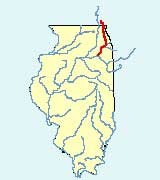
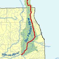
Location: The Des Plaines River, the longest stream within the Chicago region, flows southward for 133 miles (105 miles in Illinois) through southern Wisconsin and northern Illinois. It eventually meets the Kankakee River southwest of Joliet to form the Illinois River, a significant tributary of the Mississippi River.
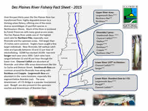
Des Plaines River Fishery Facts
(Click on image for expanded view.)
Description: At its widest point, the Des Plaines River is approximately 180 feet wide. The narrower sections are closer to 30 feet wide. The average width of the river is between 40 and 100 feet. Depth varies from location to location, but the average depth of the Des Plaines River is 3 feet during normal water levels.
The Des Plaines River is easily fished from shore, canoe/kayak or by wading. Much of the bottom is a combination of rock and silt, so care should be taken when wading.
Fishing Forecast:
Species |
Rank |
Avg Wt. |
Avg. |
Fishing Tips |
Good |
N/A |
N/A | Although widespread throughout the Des Plaines, abundance was higher at the upstream, lower gradient locations, particularly at Wadsworth and Belvidere Roads. However, quality-sized fish made up only 12% of the catch. | |
Very Good |
N/A |
N/A | Catch rates throughout the river were 25/hr. Larger fish were more abundant downstream of Riverside, especially at Lemont Road and Isle La Cache. | |
Excellent |
N/A |
N/A | Catch rates were 4/hr throughout the river. Sizes ranged from 6-26". Fourteen of 41 Pike were > 21". | |
Good |
N/A |
N/A | Catch rates throughout the river were 20 fish/hr. Highest catch rates were found at the former Dam #2, Riverside and Lemont road. | |
Good |
N/A |
N/A | IDNR has stocked an average of 19,000 2-inch fingerlings per year since 2000, primarily in the lower river. Catch rates ranged from 4-21/hr in higher gradient areas, with fish ranging from 6-19" in length. | |
Fair |
N/A |
N/A | Catch rate was over 120/hr in 2020 at Isle La Cache, near Romeoville - a record high for the Des Plaines River. All size classes were present with 15/hr in the 14 - 16" size range. Young-of-the-year were abundant indicating very good reproduction, which was a first for the previously degraded river. | |
Note: The upper Des Plaines River runs primarily through forest preserve property of Cook County, IL and Lake County, IL. Much of the shoreline is on property owned by the Cook County Forest Preserve District and the Lake County Forest Preserve District. Some portions do run through land that is not publicly owned so please be aware of signs indicating private property. There are many access points on the river, as well as Kayak/Canoe launch points:
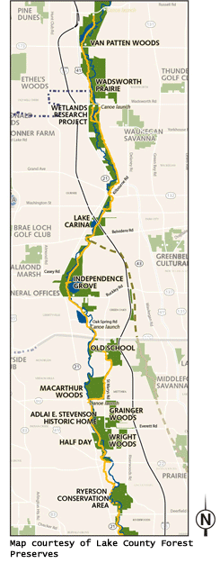
Click on image for expanded view.
River Access Areas
- Van Patton Woods (near Wadsworth, IL)
- Independence Grove (near Libertyville, IL)
- Adler Memorial Park (near Libertyville, IL)
- Riverside Park (near Libertyville, IL)
- Red Top Park (near Libertyville, IL)
- Half Day Forest Preserve (near Vernon Hills, IL)
- Spring Lake Park (near Lincolnshire, IL)
- Potawatomi Wood s(near Wheeling and Northbrook, IL)
- Dam #1 Woods (near Wheeling, IL)
- Allison Woods (Northbrook, IL)
- Lake Avenue Woods – East (near Glenview and Mt. Prospect, IL)
- Dam #2 Woods (near Mt. Prospect, IL)
- Big Bend Lake (near Des Plaines, IL)
- Northwestern Woods (near Des Plaines, IL)
- Campground Road Woods (Des Plaines, IL)
- Iroquois Woods/Touhy Dam (Park Ridge, IL)
- Dam #4 Woods East (Park Ridge, IL)
- Robinson Woods (Near Chicago, Rosemont, and Schiller Park, IL)
- Schiller Woods (near Chicago and Schiller, Park, IL)
- Thatcher Woods (near River Forest, IL)
Canoe/Kayak launch areas
- Van Patton Woods Canoe Launch
- Wadsworth Road Canoe Launch
- Independence Grove Canoe Launch
- Oak Spring Canoe Launch
- Rt. 60 Canoe Launch Launch
- Dam #2 Canoe Launch
- Irving Park Launch
Des Plaines Fish and Wildlife Area Information